- Kamas, UT is located just 16 miles east of Park City.
- Take a drive down the picturesque Mirror Lake Scenic Byway.
- Camp and explore thousands of acres in the Uinta and Wasatch Mountains.
- Take the 3-mile Crystal Lake Loop trail for an enjoyable day hike.
- Boat or swim in Jordanelle Reservoir.
Overview
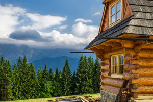
Kamas, Utah is situated in a valley between the Uinta and Wasatch Mountain Ranges. A perfect base for outdoor activities, visitors have miles of pristine landscapes to explore in just about every direction.
Location
Kamas is located in Summit County, Utah, 16 miles east of Park City.
Services/Amenities
Kamas accommodation facilities mainly include resorts, mountain lodges, inns, RV parks and campgrounds. Dining options include classic American dishes at grills, drive-ins, and cafes and as well as southwestern and Italian cuisine.
Activities
Most Kamas activities take place in the Uinta and Wasatch Mountains Ranges, National Forest, and nearby state parks and recreation areas.
Several National Forest camping areas are located close to Kamas. Pitch a tent at Beaver Creek, Soapstone or Mill Hollow Campground.
Hiking trails are easy to find with distances and difficulty levels to suit all abilities. Try the Crystal Lake Loop trail for a short day hike or attack the 16-mile Soapstone Basin Loop.
Enjoy wintertime activities at nearby ski resorts and on local roads and trails. Cross-country ski, snowmobile and snowshoe, ice fish on a reservoir, or curl up around a fireplace at one of the local resorts.
Attractions
Kamas is situated on the western edge of Kamas Wildlife Management Area and is one of four ranger districts in Wasatch-Cache National Forest. Visitors may enjoy a myriad of recreational activities during the day including hiking, fishing, biking, and more.
Mirror Lake Scenic Byway (UT-150) runs through beautiful alpine landscapes between Kamas and Evanston, WY. Highlights along the 70 mile journey include plenty of wildlife, views of Provo River, Mirror Lake, and Bald Mountain.
Getting Here
From Park City, travel 16 miles east on UT-248 to reach Kamas. Just a few miles outside of Park City, Jordanelle Reservoir will be in sight to the south. Pause for a picnic lunch around the lake before continuing to Kamas.